When I was growing up, my family took a summer vacation trip most years, usually two weeks of camping somewhere. Often, the trip was to the redwood forests in Mendocino County, California, an area we all loved. In 1952, when a combination of factors made our previous locations unavailable, our family doctor offered the use of his cabin near Lake Tahoe.
I had been in a lot of hilly country in my native California, but I had never been to the real mountains before. That first trip was a revelation, and quickly made The Mountains my favorite place.
The doctor’s cabin was at Lily Lake, located just outside the southeast boundary of what is now the Desolation Wilderness. To reach it, we drove from near the south end of Lake Tahoe west around the side of Fallen Leaf Lake to the lodge at its west end. The road to the lodge was paved when we first went there in 1952, but it was very twisty (built around the trees, not through them) and only about a car-and-a-half wide. There were quite a few cabins (some of them pretty fancy) around the edge of the lake, many of them built on Forest Service land under long-term lease. By ‘50s standards, Fallen Leaf was already a busy place.
From near the lodge, we took an unpaved rocky, rutted, road another mile or so to Lily Lake. It is a small, cup-shaped lake, at about the 6000 foot elevation, located in the forest below a prominent cliff named Indian Rock. As my first destination in the mountains, it was a pretty spectacular setting.
The cabin (one of a half dozen or so around the lake, built under Forest Service permits) was on the west shore, and was reached either by boat or by a half-mile walk around the south side of the lake. We walked that first time. I remember the cabin as being fairly new - clean, bright, and very upscale compared to “cabins” I saw, and occupied, in later years.
I was in Seventh (or Eighth!) Heaven. There were wonderful vistas, and trails, and conifers, and granite boulders, and bird species I had never seen before. I wandered everywhere in the vicinity of the cabin. I don’t think Dad and Mom knew where I was most of the time. I was pretty much of a loner, anyway, so being mostly off by myself was nothing new. On one of my scrambles around, I slipped on a little granite cliff, and tore a big gash in my left knee. I limped back to the cabin, bleeding profusely. The tear should have had a few stitches, but we were a long way from a doctor (even though in a doctor’s cabin!), so Mom put a butterfly bandage on it, and I went back to my ramblings. The scar, which was about an inch long, was visible all my life.
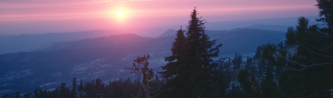
As great as were the immediate environs of the cabin, I soon found that the real adventures lay beyond. From Lily Lake, the Forest Service road (just a rutted jeep trail in 1952) continued on another mile or so to the old Glen Alpine Springs resort (unoccupied at that time, I think[1]), and the boundary of the Desolation Valley Primitive Area[2] Only a few years after this, the area was “discovered” by backpackers and day hikers, but in 1952 it was rare to see another person once you left the road. We hiked into the Primitive Area a couple times that year, including some of the family hiking all the way to the top of Mt. Tallac. That was a long day, about 12 miles round trip, and with the summit at 9,735 feet above sea level, was the highest I’d ever been and my first time in an alpine area. I loved it.
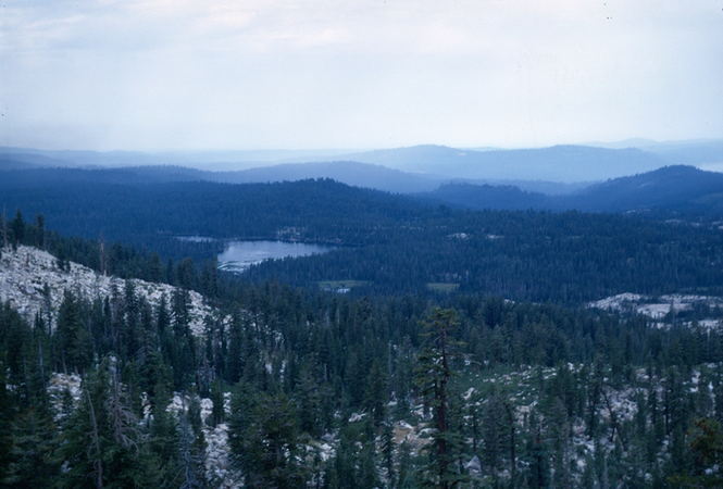
We returned to Lily Lake again in 1953. With another year under my belt, and with my knowledge of the area, I branched out and covered a lot more ground. With family members, I hiked a time or two over the Indian Rock ridge to the Angora Lakes, even in those days a heavily used resort, reached by a side road coming from Fallen Leaf. Some of us also bushwhacked out onto Indian Rock itself, to where we could look down into the bowl of Lily Lake. Mostly, I hiked by myself. I went to Glen Alpine several times, and hiked to several lakes (Grass, Heather, Susie, Half Moon). There was a trail (apparently no longer maintained) that left from Lily Lake and crossed a divide past Ralston Peak toward the Echo Lakes, and I hiked up that a ways a time or two, also. My biggest adventure that year was a solo hike to Dick’s Pass, covering about 15 miles and an elevation at the pass of almost 9,400 feet, with an impromptu cross-country slip and slide from near the summit straight down to Half Moon Lake.
I didn’t have a camera on either Desolation vacation, and didn’t keep any kind of journal. My memories are just that – the pictures I have in my head, and my memories of how much I enjoyed myself.
* * *
Wright’s Lake 1968
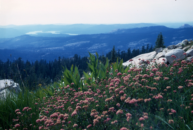
Except for my odd snowy hike on Mt. Tallac in 1957 (see “The Snow Cross,” link above), I never was able to get back into the Desolation Wilderness. One early summer in the mid ‘60s,” Sally and I drove to Echo Lakes with the intent of hiking into the area, but it had been a late winter, and the entire area above about 7000 feet was still completely snow-covered. My last try came in 1968, when I decided to see what the west side of the area was like. My Dad and I drove Highway 50 almost to Echo Summit, then took a side road north to Wright’s Lake. My intent was to get us to some of the high lakes below the Crystal Range, to get another taste of open granite terrain. We hiked the Twin Lakes Trail for a couple of miles, and cleared the main forested area, but by then Dad’s foot and leg (which had given him on and off trouble throughout his adult life) were painful. We found a spot near the trail where some previous hikers had built a wall of boulders, probably as shelter from the wind, and decided that was our campsite. Dad immediately took advantage of flat ground to take a nap, while I wandered around, enjoying the wildflowers and the views.
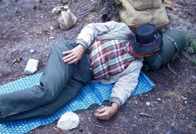
It is a common saying – and mostly true – that it doesn’t rain after dark in the summer in the Sierra Nevada. You may get soaked from afternoon thunderstorms, but it is almost always clear and dry by sundown. Consequently, a lot of backpackers don’t carry tents with them. This trip broke the rain rule, and we had light precipitation that fell on us most of the night. We had a tarp with us that we arranged over the rock wall to make somewhat of a shelter. We weren’t miserable, but we certainly got wet.
In the morning, Dad’s leg was better but, rather than risk any real injury, we decided to forego the rest of our planned trip. We returned to Wright’s Lake, and drove back to the Bay Area.
* * *
This is an odd little essay, with no big events or particular excitement recorded. Still, I wanted to write it because, as matter-of-fact as it may read, it really was the trip that opened The Mountains to me. The straightforward bits of memory in print are just shadows of the vivid scenes and feelings that came back to me as I was writing them down. Desolation was a great introduction and impetus for what was to come.
I also wanted to write this piece to say more about Desolation Wilderness, and wildernesses, in general. In the 1950s, it often seemed like I had the whole Primitive Area to myself. Clearly, there were other hikers and campers, but they were so well separated by time and space that it was possible to be out for a day without meeting anyone. Today, Desolation is the most heavily used National Wilderness in the system. That is not a good claim to fame for a Wilderness!
According to the 1964 Wilderness Act, an area designated under the Act is one “where the earth and its community of life are untrammeled by man;’” that “generally appears to have been affected primarily by the forces of nature, with the imprint of man's work substantially unnoticeable; (and) has outstanding opportunities for solitude or a primitive and unconfined type of recreation.” But a 2003 trail guide[3] to the area described Desolation as “too crowded to be considered a wilderness in the strictest sense of the word;” and: “Although wilderness areas should be pristine havens for solitude, don’t expect to find any unless you get off the beaten path.” A friend who backpacked into the area in the 1990s confirmed those views; it was too crowded, and there were too many signs of extreme human occupancy – erosion, litter, damaged vegetation, and human waste.
Desolation is a victim of national changes, and also a product of its own location and nature. In the 1950s, people were still recovering from the War Years, and just beginning to branch out to enjoy the outdoors. As roads and cars both increased, camping spread to areas farther from the cities. Also in the 1950s, people like me were getting most of their hiking and backpacking gear from Army surplus store – heavy boots, heavy sleeping bags, and heavy backpacks. Extended trips needed light-weight equipment, and also light-weight food. Army K-rations, powdered eggs and such were available, but not very pleasant for more than an occasional meal. Development during the 1960s of a lot of new gear made for backpacking, and a lot of dehydrated foods (some pretty good!), encouraged a lot of people to explore farther from their cars and campgrounds.
It was inevitable that Desolation would be one of the areas quickly found by the new wave of hikers and backpackers. Lake Tahoe was turning into a major destination for tourism and outdoor recreation, and Desolation was right there, ready for use. Ironically, its change from a Primitive Area to a member of the National Wilderness Preservation System – which involved a lot of publicity, but almost no difference in management – resulted in many more people knowing about the area, and also made it a more attractive destination (like wanting to see a national park, rather than just a national forest area). By almost everyone’s opinion, public use was out of control.
The Forest Service has tried to save some of the wilderness qualities by limiting the number of overnight campers, requiring permits by both backpackers and day hikers, and prohibiting campfires. No doubt the rules have helped, but Desolation is just too accessible. Averaging only 12 miles long and eight miles wide, and with a variety of entry points, there are few locations that can’t be reached by day hikers, and none beyond the capabilities of even the least ambitious overnighters. And despite its growing reputation for overcrowding, the crowds keep coming, spurred on, no doubt, by over 25 trail guides still in print, and more being published. The scenery is still there, and for folks who haven’t experienced the alternatives, it must offer an unique experience and a wonderful change of pace.
* * *
There are a number of places I have loved, and to which I would really like to have returned. Desolation isn’t one of them. I’d rather remember it through the eyes of a 12 year old boy, alone atop a 9000-foot pass, dreaming about more mountains that he would see in the future. Those are good memories.
* * *
FOOTNOTES
[1] Glen Alpine Springs, opened in 1878, was the first family resort developed in the Lake Tahoe area. It accommodated hundreds of people up until the 1940s, at least. I have read that it didn’t close completely until 1960, but I don’t think much was happening after World War II. I remember the buildings, but I don’t remember ever seeing any activity there. I’m sure I never saw anybody driving on the road.
[2] The U. S. Forest Service designated the Desolation Valley Primitive Area in 1931, a management decision “to maintain primitive conditions of transportation, subsistence, habitation, and environment to the fullest degree compatible with their highest public use" (Regulation L-20). What such a designation meant in practice was a little uncertain, but in general it stayed a lightly-managed, motor vehicle-free environment. Following the passage of the Wilderness Act in 964, it became a part of the National Wilderness Preservation System, and was named the Desolation Wilderness.
[3] Schaffer, J. P. 2003. Desolation Wilderness and the South Lake Tahoe Basin. Berkeley, California: Wilderness Press.
To the Writing It Down Homepage
Leave a Comment: symbios@condortales.com